Home Home
  • Home
  • 25 years
  • News
  • Sectors
    • City councils
    • Public authorities
    • Mobility and sustainability
    • Service networks
    • Companies and businesses
    • Logistics
  • Tools
    • Cercalia
    • enMapa
    • Recitty
    • Custom solutions
  • Contact
Contact

Breadcrumb

  1. Home
  2. Touch screen field application analyze potable water tablet LIMS labware

A Touch screen application to inform of field-work water samples

Submitted by Anonymous (not verified) on Fri, 02/09/2018 - 00:00
Image
ematsa

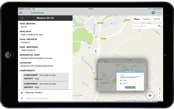
EMATSA has deployed a mobile application (app) that allows laboratory samplers to take in-situ data analysis of water samples, as well as inform the samples made during their work day. This mobile application also takes into account the quality criteria of the laboratory, assuming that each time a field technician comes out, he must inform the necessary standards for quality control. The samples are organized by sampling routes and by date, which guarantees that each sampler receives on his ipad the samples and the parameters that he has to report in a work day. Once the quality parameters and the analytical results of the samples are informed, these values are automatically incorporated into the laboratory LIMS system. In addition, samples and sampling points are shown on the google map. The geolocation that allows the ipads and the fact that the location of the sampling points is known allow us to calculate the optimal path for the sampler by making the work easier. The application has been developed by the iOS operating system and is implemented in touch tablets iPAD, connected to the internet through 4G. The application can also work offline with automatic synchronization once it retrieves the connection and has been developed with the collaboration of Nexus Geographics.

EMATSA, Municipal Mixed Company of Aigües de Tarragona SA, is a company of the Tarragona City Council and Sorea (SUEZ group) that contributes to the growth and development of Tarragona, La Canonja, Els Pallaresos and El Catllar where it manages the integral water cycle to more than 145,000 inhabitants.

Categories

Congress and conferences
Transport and infrastructure
NexusTeam
GIS Solutions for City Councils
Smart Mobility
City Councils
Awards
Spatial intelligence
Geolocation
Article
APPS

Related news

pisos
Tue, 02/20/2018 - 00:00
Maps with 3D buildings with apartments and houses on the real estate portal Pisos.com
ematsa
Fri, 02/09/2018 - 00:00
A Touch screen application to inform of field-work water samples
TUS
Mon, 01/15/2018 - 00:00
GIS system of mobility and public transportation of Sabadell
aparkb
Fri, 01/05/2018 - 00:00
Nexus Geographics chosen by B:SM for the development and implementation of the "Where to park for minutes" platform
CONTACT
  • Barcelona Office
    Aragó 264 4, 08007 Barcelona
  • Girona Office
    Joaquim Botet Sisó 6, 17003 Girona
  • Madrid Office
    Paseo de la Habana 9-11, 28036 Madrid
  • +34 93 0172728
    info@nexusgeographics.com
  • TwitterYoutubeLinkedin Instagram
  • energia renovableaeonorENSISOPymeInnovadora
SECTORS
  • City councils
  • Public authorities
  • Mobility and sustainability
  • Service networks
  • Companies and businesses
  • Logistics
NEXUS
  • News
  • Work with us
  • Cercalia
  • enMapa
  • reCitty
  • Contact
OTHERS
  • BusManager
  • Routing Reparto
Logo eulogo soclogo next genlogo generalitat
  • Quality and safety policy
  • Cookies policy
  • Privacity policy
  • Social media policy
  • Legal advice
  • Home
  • 25 years
  • News
  • Sectors
    • City councils
    • Public authorities
    • Mobility and sustainability
    • Service networks
    • Companies and businesses
    • Logistics
  • Tools
    • Cercalia
    • enMapa
    • Recitty
    • Custom solutions
  • Contact