Home Home
  • Home
  • 25 years
  • News
  • Sectors
    • City councils
    • Public authorities
    • Mobility and sustainability
      • Smou
    • Service networks
    • Companies and businesses
    • Logistics
  • Tools
    • Cercalia
    • enMapa
    • Recitty
    • Custom solutions
  • Contact
    • Work with us
Contact

Error message

Deprecated function: Return type of Drupal\google_analytics\Component\Render\GoogleAnalyticsJavaScriptSnippet::jsonSerialize() should either be compatible with JsonSerializable::jsonSerialize(): mixed, or the #[\ReturnTypeWillChange] attribute should be used to temporarily suppress the notice in include() (line 10 of modules/google_analytics/src/Component/Render/GoogleAnalyticsJavaScriptSnippet.php).

Andorra's government launched an innovative mapping website

Submitted by admin on Tue, 03/17/2015 - 15:49
Image
Andorra

Nexus Geografics has been commissioned to update and improve the geoportal of Spatial Data Infrastructure (SDI) of Andorra, creating a bespoke service to meet the needs of Government and citizens.

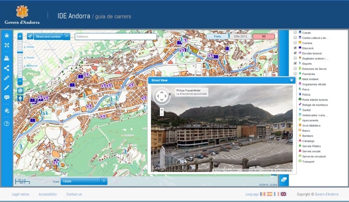
Among other features, the current SDI stands for aesthetic and performance improvements as well as it implemented the navigation map viewer; besides, a significant improvement in the approach of geographic data to inexperienced users has been developed so the user has a specific, accessible and useful viewer: the city guide. Finally, users also have a new, aesthetic and functional metadata catalog and a nomenclature system.

Thus, the Andorran Government offers a useful, practical and innovative service that will allow anyone to find accurate geographic data for Andorra, from anywhere and at anytime. The website, which is already available, is the following: http://www.cartografia.ad/geoportal-cas (Spanish website).

With a population of 84,000 and an area of 468 km2, Andorra is a state located in the Pyrenees between Catalonia (Spain) and France, that offers a good quality of life for its citizens.

Categories

Congress and conferences
Transport and infrastructure
NexusTeam
GIS Solutions for City Councils
Smart Mobility
City Councils
Awards
Spatial intelligence
Geolocation
Article
APPS

Related news

pisos
Tue, 02/20/2018 - 00:00
Maps with 3D buildings with apartments and houses on the real estate portal Pisos.com
ematsa
Fri, 02/09/2018 - 00:00
A Touch screen application to inform of field-work water samples
TUS
Mon, 01/15/2018 - 00:00
GIS system of mobility and public transportation of Sabadell
aparkb
Fri, 01/05/2018 - 00:00
Nexus Geographics chosen by B:SM for the development and implementation of the "Where to park for minutes" platform
CONTACT
  • Barcelona Office
    Aragó 264 4, 08007 Barcelona
  • Girona Office
    Joaquim Botet Sisó 6, 17003 Girona
  • Madrid Office
    Paseo de la Habana 9-11, 28036 Madrid
  • +34 93 0172728
    info@nexusgeographics.com
  • TwitterYoutubeLinkedin Instagram
SECTORS
  • City councils
  • Public authorities
  • Mobility and sustainability
  • Service networks
  • Companies and businesses
  • Logistics
NEXUS
  • News
  • Work with us
  • Cercalia
  • enMapa
  • reCitty
  • Contact
OTHERS
  • BusManager
  • Routing Reparto
logo soclogo generalitatLogo eulogo next genenergia renovableENS
aeonorISO
Sello PYME INNOVADORA 11/02/2028
PYME INNOVADORA
Válido hasta el 11 de febrero de 2028
escudo de MEIC 11/02/2028
  • Quality and safety policy
  • Cookies policy
  • Privacity policy
  • Social media policy
  • Legal advice
  • Home
  • 25 years
  • News
  • Sectors
    • City councils
    • Public authorities
    • Mobility and sustainability
    • Service networks
    • Companies and businesses
    • Logistics
  • Tools
    • Cercalia
    • enMapa
    • Recitty
    • Custom solutions
  • Contact
    • Work with us